CAUTION: TVD’s in horizontal wells could mislead you
Don’t rely too much on those TVD values toward the toe of your lateral. All the sources of wellbore positional uncertainty can add up to significant cumulative TVD error. This post is about one of them- perhaps the most significant: Survey Spacing- and it’s impact on TVD.
The Survey Spacing study
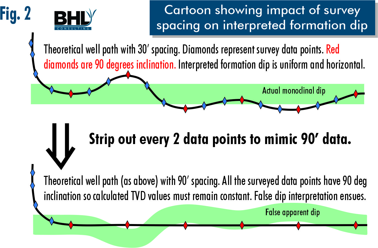
To understand how survey spacing impacts TVD (and dip) we plotted several actual wells that were surveyed at every joint (~30’ spacing) from KOP to TD. To replicate the most common survey spacing (90’) we removed every two data points from the 30’ data.
The Results
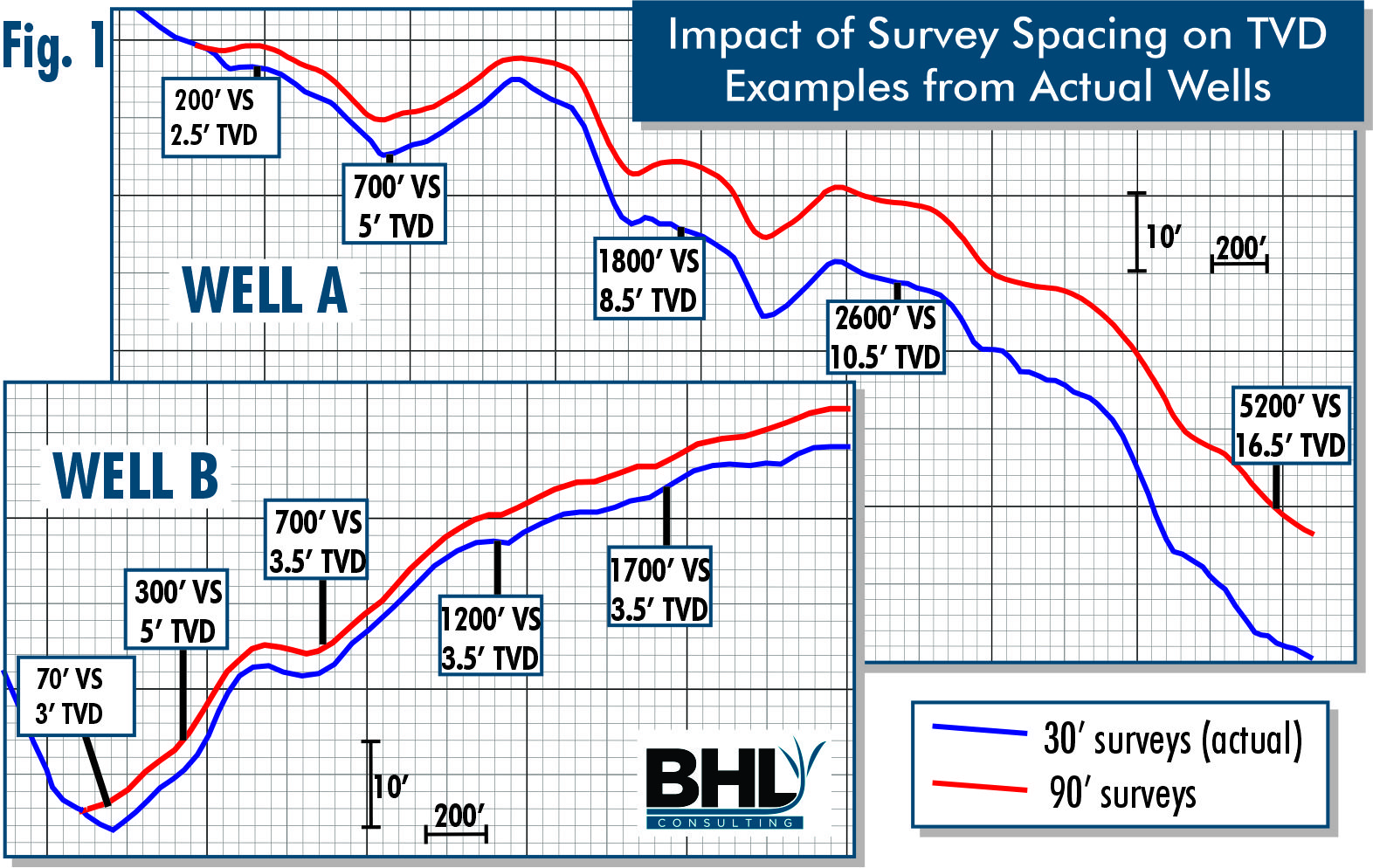
Well ‘A’:
- 700’ from EOC (End-of-Curve), 90’ surveys plot the well path 5’ TVD shallower than 30’ surveys
- 1800’ from EOC, 90’ surveys show the well path 8.5’ TVD shallower than 30’ surveys
- 5200’ from EOC, 90’ surveys show the well path 16.5’ TVD shallower than 30’ surveys
Well ‘B’:
- 70’ from EOC (Yes, only seventy feet!), 90’ surveys post the well path 5’ TVD shallower than 30’ surveys
- 700’ from EOC, the gap narrows to only 3.5’ TVD difference
Okay, why is this happening?
You don’t know what you don’t know. If there are no surveys to indicate that the well path wandered up or down and then leveled off between 90’ surveys, then we have no way of knowing that TVD changed. Remember- TVD isn’t directly measured- it’s calculated from MD and INC. So, if inclination is wrong, TVD values aren’t reliable.
So, if (for example) our samples and LWD curves tell us that we’re in the “A-Zone” at 9950’ TVD of the well path, then we can only conclude that the A-Zone is at 9950’ TVD at that point in the lateral.

Figure 2 shows effects of widely spaced surveys on both INC and TVD, first for the wellbore, and then the formation. The upper panel shows a lateral, hypothetically surveyed every 30’ with target zone in green. The lower panel shows the same lateral surveyed every 90’. The blue and red diamonds represent 30’ and 90’ surveys, respectively. Also, note that to keep this cartoon simple, the red diamonds also represent 90 degrees inclination.
Think of it this way: the surveys tell us the wellbore remained 90-degrees flat, and we know that we went out the top of the zone. The only possible conclusion? The formation turned down.
“But, we run 90-ft surveys and we’ve never seen this problem!”
Well, we can’t and we won’t see these effects, unless we have closer-spaced surveys to use as benchmark data, and we deliberately look for the impact. It is all very well documented in the literature and has been for decades. However, these effects are not always at the forefront of everyone’s mind. So we’re sharing this with you to remind you of the impacts.
Also remember that if we compared 30’ surveys to 10’ surveys, we would see some of the same effects, though usually with less range of uncertainty/error.
What about Image Logs & “Continuous Inclination” survey tools? Don’t they eliminate this problem?
Image logs cannot directly help, despite the appearance of exquisitely finely detailed information. They remain totally dependent upon well path TVD & INC as the bases for all structural details that they provide. Calculated reservoir thickness is also skewed by these effects.
Continuous-Inclination data can greatly help in this regard, but the tools are expensive and not deployed as often.
Why don’t we always run 30’ survey data?
Rig time is expensive and more surveys take more time. It all comes down to Cost-Benefit analysis. Do the well economics support the additional rig time-cost of closer-spaced surveys? If more accurate surveys make the program sub-economic, a certain amount of uncertainty is usually a better choice.
The extra cost maybe worthwhile if we’re chasing thin targets with serious implications if we exit the target. Any play where targets are thin and/or bound above/below by high risk intervals that threaten the well bores stability, or possibly excessive water production are candidates for closer-spaced surveys.
Takeaways for Anybody Who Has to Live with Geosteering Results (much like our previous post on survey spacing and impact on interpreted formation dip):
- Geologic Structure and Reservoir Geometry in a geosteering interpretation are 100% based upon well path position. “Error-In-Error-Out” always applies.
- Widely-spaced surveys alone can make a geosteering interpretation fail to match pre-drill mapping and the drill plan.
- Apparent wobbles and wrinkles in formation dip may be falsely created from localized wellbore positional errors
- More survey data reduces wellbore positional uncertainty and error.
- Never believe that we know TVD depth to the nearest single foot, much less fractions of a foot. We don’t.
- Where out-of-zone drilling is critical, it may be appropriate to increasing survey spacing.
- But it is always a Cost-vs-Benefit question that has to stack up against the well’s economics.
As always, let us hear from you! Please comment below or contact us directly. If you have a data set with closer-spaced surveys and you’d like for us to model it like we’ve done here, let us know.
This post comes from the original content and ideas of Raymond Woodward. Raymond is a co-author on this blog. He’s geologist with more than 40 years experience in oil and gas and original founder of BHL Consulting.


0 Comments